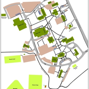
A team at the University of Maine at Presque Isle has completed a unique accessibility mapping project, creating a GIS-based map that pinpoints all of the accessible features on campus, from handicap parking spaces to wheelchair accessible ramps and entryways.
“This makes UMPI a leader in this area for our community and in Maine higher education,” Dr. Jacqui Lowman, UMPI Diversity, Equity, and Inclusion (DEI) Council co-chair, said. “This will really make a difference for so many.”
The project was years in the making but began in earnest in Spring 2021. Dr. Lowman—a longtime wheelchair user with faithful service dogs Saint and Dusty by her side—has long known where all the accessible doors and parking spaces are on campus, but she was well aware that anyone new to campus might not be able to find these resources easily: “We realized that the people (and dogs) to get this done were/are us,” she said.
After bringing it forth during UMPI’s DEI Council meetings, a small team developed. Pam Easler, administrative specialist with the College of Arts and Sciences, took on the documentation work and Dr. Chunzeng Wang, Professor of Earth and Environmental Sciences, accepted the task of creating the actual map. Using GIS (Geographic Information Systems) resources, Dr. Wang printed out a large map of campus on which Dr. Lowman and Easler could annotate features. Joe Moir, Director of Facilities Management, provided building floor plans.
Armed with these documents, Dr. Lowman and Easler mapped the paths, accessible entrances, curb cuts, parking spaces—including van-accessible spaces which are much wider to allow wheelchair users to safely enter and exit the van using a ramp or lift, accessible restrooms, and elevators. They also noted the accessible outdoor bleachers at the Park Family Field: “They are truly thoughtful and amazing,” she said.
As they traveled through campus, Easler took notes and measurements.
“Looking at it through the eyes of people who would not know the campus, we realized that there are gaps in our signage,” Dr. Lowman said. “We’ve recommended adding in more signs and proposed locations, as well as recommending a few more accessible parking spaces.”
Dr. Wang then took all that information and input the data into a GIS map. GIS is an information system that captures, stores, analyzes, and displays geographic information. The final version of the map was completed this fall and will be placed on the campus website as a resource for the campus, community, and all visitors. In addition, signage is on the way, the parking spaces recommendation has been accepted, and a digital app is in the works by Dr. Rafiul Hassan, Associate Professor of Computer Science, and his students.
While the project is in its final stages, Dr. Lowman said she’s happy to do it all over again—serving as a resource on accessibility for the greater community and other campuses.
“We are not the final word on the subject, but being a wheelchair user offers some very useful insights and creativity,” she said. “We’d be happy to help our community figure out some ideas for accessibility. Where there’s a will, there’s a way.”
For more information about this effort, or to connect with Dr. Lowman on an accessibility project, call 207-768-9745 or email jacquelyn.lowman@maine.edu.